What is the Heart of the Continent:
An ancient landscape … in transition
An International Treasure
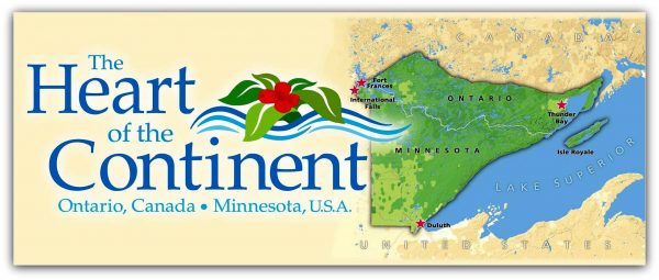
Spanning the international border between northeastern Minnesota and northwestern Ontario lies the largest expanse of public green space in the heart of North America. This “heart of the continent” region includes several well-loved parks and forests: Quetico Provincial Park, Superior National Forest (including the Boundary Waters Canoe Area Wilderness), Voyageurs National Park, and numerous smaller Minnesota state forests and parks and Ontario provincial parks. Here’s a brief summary of how natural and human forces have shaped and continue to shape this international treasure, the Heart of the Continent.

An Ancient Landscape
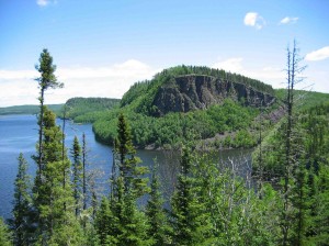
The rugged features of this landscape tell us a lot about the ancient forces that gave it birth. Indeed, there is something about geologic time that allows one the “luxury of perspective.” Jagged topography, long, narrow lakes, steep cliffs and plunging shorelines in this region reflect the folding, tilting and uplift of ancient Precambrian granite formations, infused with Gabbroic magma and layers of sedimentary rock, hardened under pressure. The abundant bedrock exposures throughout the area reveal some of the oldest rock on the surface of the planet. Greenstone outcroppings for example, are nearly 3 billion years old.
Glaciers of the last Ice Age left a huge imprint on this region. Evidence of gouging, scouring and scraping by massive, continental-scale glaciers abounds, from the grooves in the ancient, exposed bedrock of the Canadian Shield to the endless chains of inter-connected lakes and rivers of the region. After the glaciers retreated, the land was forever changed. A landscape of thin, nutrient-poor soils over bedrock emerged. Giant, buried ice blocks formed kettle lakes and glacial deposits formed sinous ridges (eskers). Early, high-water stages of Glacial Lake Agassiz flooded low-lying areas, depositing richer sediments, supporting future forests.
A Dynamic Ecosystem
In the ten-thousand years since the last glaciers, ecological forces have continued to shape the landscape. Today, the region’s geologic structure combines with climate and watershed patterns to present a great variety of habitats for living things. Broad-scale disturbances such as wind and fire constantly yield a shifting mosaic of vegetation patterns. These large-scale disturbances, along with smaller-scale disturbances such as beaver activity and gaps created by single tree-falls, have created niches for plants and animals, and in so doing enriched biodiversity throughout the ecosystem.
Encompassing the headwaters of three continental watersheds, this region sends its waters in three directions: north to Hudson Bay, south to the Gulf of Mexico, and east, through Lake Superior, to the St. Lawrence Seaway. The Rainy River serves as both a hydrological and historical connector for the whole area; a 19th century treaty made it the official boundary between Canada and the United States.

An Intersection of Cultures and Values
Ever since the glaciers receded, people have lived in, been shaped by, and helped shape the heart of the continent. The earliest humans to occupy the nacent landscape left by retreating glaciers were members of the Paleo Indian culture, arriving some 8,000-12,000 years ago. Several aboriginal groups have inhabited the region since, with the Anishinabe becoming widely established in the 1600s. Using locally abundant natural resources, these aboriginal people adapted their cultures, lifestyles, and technologies specifically to meet the challenges of surviving in this new environment. Their invention of the canoe revolutionized travel, advancing trade and cultural exchange along the major water routes of this area.
To the early European explorers, this region was seen as a resource to be extracted in order to build wealth. Early in the 1600s, the French began exploring the inland waterways of the heart of the continent to exploit the rich wildlife resources of the region. Throughout that century and the next, both English fur traders and French voyageurs established remote posts at key locations along the water routes, where the Anishinabe people exchanged furs for trade goods. By the late 1700s, furs from as far away as Lake Athabasca were being transported by canoe along these waterways and across Lake Superior to Montreal, for shipment to European markets.
After the beaver populations (and fur trade) declined in the 1800s, European descendants sought other ways to benefit from the vast resources they saw. Surveyors began systematically assessing the landscape for its vast timber resources. Extensive logging followed in the early 1900s, with much of the virgin pine forests felled for the construction of burgeoning cities far away. (As a byproduct, large, catastrophic fires raged through the slash.) At the same time, mining of vast iron ore deposits provided the raw materials for a growing steel industry.
It was during this era of extraction that a concern for conservation of natural resources and wild places began to surface. In 1909, Quetico Provincial Park and the Superior National Forest were established. Recreation and tourism grew and, in subsequent years, citizens rallied for the preservation of remaining wilderness areas. Voyageurs National Park was established in 1975. In 1978, after long political struggles, both the Quetico and Boundary Waters Canoe Area Wildernesses were designated. In recent decades, additional publicly managed heritage lands such as state and provincial parks, conservation areas, and historic sites have enhanced the immense conservation value of this landscape.

A Landscape in Transition
While physical, biological and political forces continue to shape the heart of the continent landscape, climate change today introduces new uncertainties. Thunderstorms will occur with greater frequency and intensity, increasing large-scale winds and fires. Plant and animal species will continue to struggle to adapt to predicted hotter, drier summers and warmer, wetter winters. Invasive species such as the gypsy moth, buckthorn, purple loosestrife, and spiny waterflea are gaining footholds.
In light of these changes, along with increasing pressures of development, there are many questions about the sustainability, viability and functioning of both human and natural communities in the region. Understanding the natural history of the heart of the continent landscape is an important first step in developing the strategies needed to sustain the unique physical, biological and cultural values of this landscape into the future.
